Hazard: WildFire#
This class is used to model the wildfire hazard using the historical data available and creating synthetic fires which are summarized into event years to establish a comprehensive probabilistic risk assessment.
The historical data used comes from the Fire Information for Resource Management System (FIRMS). They collect temperatures from the following satellite instruments:
- Moderate Resolution Imaging Spectroradiometer  (MODIS): Near real time or standard quality data with 1 km resolution. Data available from November 2000 to present.

- Visible Infrared Imaging Radiometer Suite (VIIRS): Near real time data with 0.375 km resolution. Data available from 20 January 2012 to present.
The data should be obtained at https://firms.modaps.eosdis.nasa.gov/download/ and saved as .csv file. Approximately 15 min after submitting the request, the data can be downloaded by checking the request status.
The WildFire class inherits from the Hazard class and has an associated hazard type WF. It provides a set_hist_fire_FIRMS() method which enables to fill the hazard with historical events, a set_hist_fire_seasons_FIRMS() method which aggregates historic events to event years, and a set_proba_fire_seasons() method which generates random event years.
Some additional notes:
in contrast to other hazards (i.e. TC) there’s no clear definition for “a wildfire event”. While some countries (i.e. US, Australia) provide very detailed reports, other’s (i.e. Chile, Indonesia) rather provide information on the whole fire season. Thus, we produce probabilistic fire seasons rather than single events to ensure global consistency. However, for case studies or calibration studies, identification of single fire events is still of importance. Thus, we differentiate in the hazard type: ‘WFsingle’ for individual fires as recognized by the algorithm, ‘WFseason’ for whole fire seasons.
Wildfires are hazards with a huge societal component - in many cases humans are not only responsible for starting one, but also for ending it (fire fighting). This means, that worst case scenarios (i.e. a wild fire spreading to down town Los Angeles) are less likely, as compared to TC risk, where it is highly likely that a strong TC strikes Manila and people have no chance to prevent that from happening. Accordingly, the probabilistic wildfires come with an even larger uncertainty than other hazard as social behaviour have a major impact on wildfires.
In our default version for creating probabilistic fire seasons, we rely fully on past data. Thus, in the default, this module is not suited to conduct studies on climate change risk. However, the generation of synthetic fire seasons can be manipulated.
We are currently working on improving the generation of probabilistic events.
This tutorial describes#
How past fires are computed
How past fire seasons are computed
How probabilistic fire seasons are generated
HISTORICAL FIRES#
A fire is defined as an event when the temporal and spatial distance of the burning centroids is close enough. There are two parameters which define the “closeness”:
- days_thres (int): temporal distance in days. Default: 2.
- clus_thres (int): factor to multiply to the centroids resolution. Used to determine the cluster maximum distance between two centroids. Default: 15.
These parameters are stored in the DataClass WF.FirmsParams
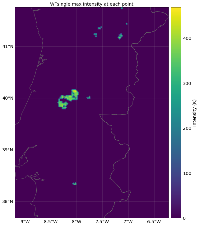
In June 2017, Portugal was hit by a series of deadly wild fires which led to 66 fatalities, more than 200 mn. USD damages and 45’000 ha burned area. With set_hist_fire_FIRMS() we can model past fire such as the ones in Portugal in 2017. The method takes FIRMS data as a dataframe (pd.df) as input. If no Centroids are defined, the method automatically defines centroids in line with the spatial extent of the FIRMS data. Hazard resolution can be modified using parameter centr_res_factor.
# Fires in Portugal 2017
import os
import pandas as pd

from climada.util.constants import DEMO_DIR
from climada_petals.hazard import WildFire

# Data downloaded for MODIS
d_path = os.path.join(DEMO_DIR, "Portugal_firms_June_2017.csv")

# read data
firms = pd.read_csv(d_path) # FIRMS data as pandas dataframe

# set up wildfire
wf_pt = WildFire()
wf_pt.set_hist_fire_FIRMS(firms, centr_res_factor=1./2.5) # we decrease the hazard resolution to 2.5 km

# plot the maximum intensity of all fires at each centroid
wf_pt.plot_intensity(event=0);
2022-05-03 22:46:05,849 - climada_petals.hazard.wildfire - WARNING - The use of WildFire.set_hist_fire_FIRMS is deprecated.Use WildFire.from_hist_fire_FIRMS .
2022-05-03 22:46:06,120 - climada.hazard.centroids.centr - INFO - Convert centroids to GeoSeries of Point shapes.
2022-05-03 22:46:08,902 - climada_petals.hazard.wildfire - INFO - Remaining fires to identify: 0.
2022-05-03 22:46:08,946 - climada_petals.hazard.wildfire - INFO - Computing intensity of 7 fires.
2022-05-03 22:46:10,539 - climada_petals.hazard.wildfire - INFO - Returning 7 fires that impacted the defined centroids.
/home/yuyue/miniconda3/envs/climada_env/lib/python3.8/site-packages/pyproj/crs/crs.py:1282: UserWarning: You will likely lose important projection information when converting to a PROJ string from another format. See: https://proj.org/faq.html#what-is-the-best-format-for-describing-coordinate-reference-systems
  proj = self._crs.to_proj4(version=version)
<GeoAxesSubplot:title={'center':'WFsingle max intensity at each point'}>
<Figure size 432x288 with 0 Axes>
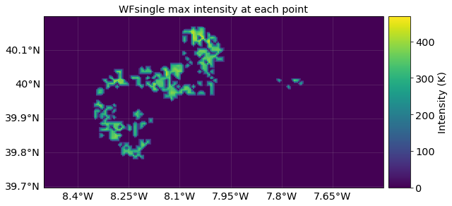
We can focus on the region around Coimbra where the most deadly fire occurred.
A given set of points or grid can be provided using the Centroids class. The events will be interpolated to the provided coordinates.
from climada.hazard import Centroids
from climada.util.constants import ONE_LAT_KM

# focus on Coimbra region with 1.0 km resolution (MODIS resolution)
res = 1.0/ONE_LAT_KM
centr_zoom = Centroids.from_pnt_bounds((-8.5, 39.7, -7.5, 40.2), res)

wf_zoom = WildFire()
wf_zoom.set_hist_fire_FIRMS(firms, centroids=centr_zoom)
wf_zoom.plot_intensity(0);
2022-05-03 22:48:33,103 - climada_petals.hazard.wildfire - WARNING - The use of WildFire.set_hist_fire_FIRMS is deprecated.Use WildFire.from_hist_fire_FIRMS .
2022-05-03 22:48:33,284 - climada_petals.hazard.wildfire - INFO - Remaining fires to identify: 0.
2022-05-03 22:48:33,320 - climada_petals.hazard.wildfire - INFO - Computing intensity of 7 fires.
2022-05-03 22:48:33,369 - climada_petals.hazard.wildfire - INFO - Returning 2 fires that impacted the defined centroids.
/home/yuyue/miniconda3/envs/climada_env/lib/python3.8/site-packages/pyproj/crs/crs.py:1282: UserWarning: You will likely lose important projection information when converting to a PROJ string from another format. See: https://proj.org/faq.html#what-is-the-best-format-for-describing-coordinate-reference-systems
  proj = self._crs.to_proj4(version=version)
<GeoAxesSubplot:title={'center':'WFsingle max intensity at each point'}>
See more infos on Wikipedia around the fire.
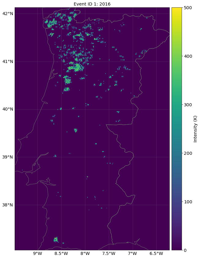
HISTORICAL FIRE SEASONS#
set_hist_fire_seasons_FIRMS() generates historic fire seasons.
These fire seasons can later be compared to the probabilistic event years for a seamless risk analysis. Note:
all the underlying events of a year are merged into one single event which is saved.
The original events, that result from the clustering are not kept in order to save space. However, this can be done setting the parameter
keep_all_eventsto true.If single fires are already calculated and assigned to centroids, they can be aggregated to seasons using
summarize_fires_to_seasons()
# load FIRMS data for 2016-2018 an select main land Portugal only
firms_seasons = pd.read_csv(os.path.join(DEMO_DIR, "Portugal_firms_2016_17_18_MODIS.csv"))
firms_seasons = firms_seasons[firms_seasons['latitude']>35.]
firms_seasons = firms_seasons[firms_seasons['longitude']>-12.]
wf_years = WildFire()
wf_years.set_hist_fire_seasons_FIRMS(firms_seasons, centr_res_factor=1/1.) # we use MODIS data resolution (1 km)
print('Events are now named according to their event year:', wf_years.event_name)
print('The number of underyling events is saved as well:', wf_years.n_fires)
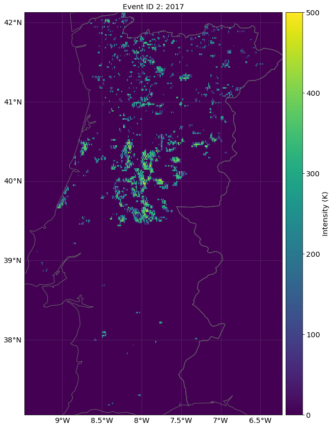
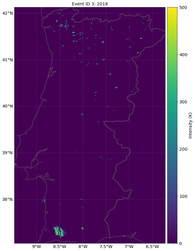
# plot the three fire seasons (2016, 2017, 2018)
wf_years.plot_intensity(1)
wf_years.plot_intensity(2)
wf_years.plot_intensity(3);
2022-05-03 22:52:26,223 - climada_petals.hazard.wildfire - WARNING - The use of WildFire.set_hist_fire_seasons_FIRMS is deprecated.Use WildFire.from_hist_fire_seasons_FIRMS .
2022-05-03 22:52:26,226 - climada_petals.hazard.wildfire - INFO - Setting up historical fires for year set.
2022-05-03 22:52:27,216 - climada.hazard.centroids.centr - INFO - Convert centroids to GeoSeries of Point shapes.
2022-05-03 22:53:01,125 - climada_petals.hazard.wildfire - INFO - Setting up historical fire seasons 2016.
2022-05-03 22:53:04,088 - climada_petals.hazard.wildfire - WARNING - The use of WildFire.set_hist_fire_FIRMS is deprecated.Use WildFire.from_hist_fire_FIRMS .
2022-05-03 22:53:05,080 - climada_petals.hazard.wildfire - INFO - Remaining fires to identify: 3388.
2022-05-03 22:53:06,153 - climada_petals.hazard.wildfire - INFO - Remaining fires to identify: 11.
2022-05-03 22:53:06,334 - climada_petals.hazard.wildfire - INFO - Remaining fires to identify: 0.
2022-05-03 22:53:07,808 - climada_petals.hazard.wildfire - INFO - Computing intensity of 113 fires.
2022-05-03 22:53:09,394 - climada_petals.hazard.wildfire - INFO - Returning 113 fires that impacted the defined centroids.
2022-05-03 22:53:11,622 - climada_petals.hazard.wildfire - INFO - Setting up historical fire seasons 2017.
2022-05-03 22:53:14,398 - climada_petals.hazard.wildfire - WARNING - The use of WildFire.set_hist_fire_FIRMS is deprecated.Use WildFire.from_hist_fire_FIRMS .
2022-05-03 22:53:15,494 - climada_petals.hazard.wildfire - INFO - Remaining fires to identify: 2392.
2022-05-03 22:53:17,040 - climada_petals.hazard.wildfire - INFO - Remaining fires to identify: 210.
2022-05-03 22:53:17,502 - climada_petals.hazard.wildfire - INFO - Remaining fires to identify: 0.
2022-05-03 22:53:20,061 - climada_petals.hazard.wildfire - INFO - Computing intensity of 201 fires.
2022-05-03 22:53:22,711 - climada_petals.hazard.wildfire - INFO - Returning 201 fires that impacted the defined centroids.
2022-05-03 22:53:27,146 - climada_petals.hazard.wildfire - INFO - Setting up historical fire seasons 2018.
2022-05-03 22:53:30,230 - climada_petals.hazard.wildfire - WARNING - The use of WildFire.set_hist_fire_FIRMS is deprecated.Use WildFire.from_hist_fire_FIRMS .
2022-05-03 22:53:31,113 - climada_petals.hazard.wildfire - INFO - Remaining fires to identify: 169.
2022-05-03 22:53:31,666 - climada_petals.hazard.wildfire - INFO - Remaining fires to identify: 0.
2022-05-03 22:53:32,795 - climada_petals.hazard.wildfire - INFO - Computing intensity of 72 fires.
2022-05-03 22:53:34,014 - climada_petals.hazard.wildfire - INFO - Returning 72 fires that impacted the defined centroids.
Events are now named according to their event year: ['2016', '2017', '2018']
The number of underyling events is saved as well: [113. 201.  72.]
/home/yuyue/miniconda3/envs/climada_env/lib/python3.8/site-packages/pyproj/crs/crs.py:1282: UserWarning: You will likely lose important projection information when converting to a PROJ string from another format. See: https://proj.org/faq.html#what-is-the-best-format-for-describing-coordinate-reference-systems
  proj = self._crs.to_proj4(version=version)
<GeoAxesSubplot:title={'center':'Event ID 3: 2018'}>
PROBABILISTIC FIRE SEASONS#
set_proba_fire_seasons() generates synthetic fire seasons.
A probabilistic fire season is generate the following way:
A fire propagation probability matrix is defined - this propagation matrix defines the probability for fire propagation on each centroid - if not further specified, the observation of historic data is used -> the fire can only propagate on centroids that burned in the past, including a blurr around these centroids - this matrix can be used to include additional information (i.e. on vegetation/land-use/elevation/population density) - the fire propagation probability matrix is stored in
wf.centroids.fire_propa_matrixas an np.array and thus can be adjusted easilyA random number n of fires that occurred in the probabilistic year is chosen. - If nothing else is specified, a random number within the range of n_fires (the number of historic events is drawn) - The range can also be specified in the input via the parameter
n_ignitionn synthetic fires are generated following this logic: - A random fire ignition point is selected (the point needs to be burnable on the fire propagation matrix) - The fire is then propagated from the ignition point as a cellular automat following these rules: 1. a neighbouring centroid to the burning centroid becomes a burning centroid with a probability p. This probability is calculated as the product of a overall fire propagation probability (default=0.21) and the centroid specific factor (which is defined on the fire propagation probability matrix) 2. an already burning centroid becomes an ember centroid (does not propagate fire anymore but is labeled as burned) 3. an ember centroid stays an ember centroid 4. The propagation stops when there is no burning centroid left. 5. The temperature provided to each centroid is randomly chosen from the corresponding historical event.
These n synthetic events are summarized into a probabilistic fire season which is then appended as a new event to the historic fire seasons
This process can be computationally expensive. Thus working on clusters might be advantageous.
Note: In the default no additional external data is included. The probabilistic event thus solely relies on past experience which likely leads to an underestimation of the current and future fire risk. The frame work allows to include climate change effects by:
defining the fire propagation probability matrix (using more data as described above)
varying the overall fire propagation probability (by i.e. linking it to a fire weather index)
varying the number of events per year (by i.e. linking it to a fire weather index)
# generate 1 probabilistic fire season for Portugal
wf_years.set_proba_fire_seasons(n_fire_seasons=1)
print('The probabilistic event year is appended to the historic:', wf_years.event_name)

# Plot the synthetic event year
wf_years.plot_intensity(event=4);
2022-05-03 23:01:35,887 - climada_petals.hazard.wildfire - INFO - Setting up probabilistic fire season with 149 fires.
2022-05-03 23:01:36,787 - climada_petals.hazard.wildfire - INFO - Created 0 fires
2022-05-03 23:01:41,790 - climada_petals.hazard.wildfire - INFO - Created 10 fires
2022-05-03 23:01:42,272 - climada_petals.hazard.wildfire - INFO - Created 20 fires
2022-05-03 23:01:42,745 - climada_petals.hazard.wildfire - INFO - Created 30 fires
2022-05-03 23:01:43,662 - climada_petals.hazard.wildfire - INFO - Created 40 fires
2022-05-03 23:01:44,495 - climada_petals.hazard.wildfire - INFO - Created 50 fires
2022-05-03 23:01:45,568 - climada_petals.hazard.wildfire - INFO - Created 60 fires
2022-05-03 23:01:46,360 - climada_petals.hazard.wildfire - INFO - Created 70 fires
2022-05-03 23:01:47,526 - climada_petals.hazard.wildfire - INFO - Created 80 fires
2022-05-03 23:01:48,494 - climada_petals.hazard.wildfire - INFO - Created 90 fires
2022-05-03 23:01:49,354 - climada_petals.hazard.wildfire - INFO - Created 100 fires
2022-05-03 23:01:50,100 - climada_petals.hazard.wildfire - INFO - Created 110 fires
2022-05-03 23:01:51,017 - climada_petals.hazard.wildfire - INFO - Created 120 fires
2022-05-03 23:01:51,618 - climada_petals.hazard.wildfire - INFO - Created 130 fires
2022-05-03 23:01:52,650 - climada_petals.hazard.wildfire - INFO - Created 140 fires
The probabilistic event year is appended to the historic: ['2016' '2017' '2018' '4']
/home/yuyue/miniconda3/envs/climada_env/lib/python3.8/site-packages/pyproj/crs/crs.py:1282: UserWarning: You will likely lose important projection information when converting to a PROJ string from another format. See: https://proj.org/faq.html#what-is-the-best-format-for-describing-coordinate-reference-systems
  proj = self._crs.to_proj4(version=version)
<GeoAxesSubplot:title={'center':'Event ID 4: 4'}>

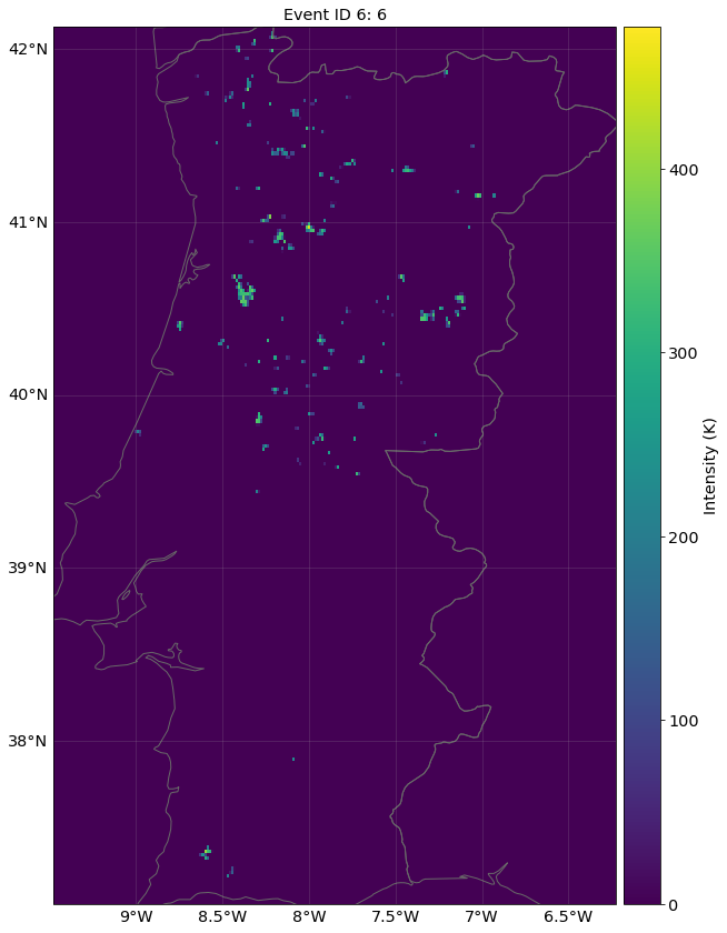
# The overall fire propagation probability is stored as a parameter and can be modified easily (default is 0.21)
wf_years.ProbaParams.prop_proba = 0.18
# The range of the number of events for a synthetic year can be modified when creating the event years
ign_range = [125,150]

wf_years.set_proba_fire_seasons(n_fire_seasons=2, n_ignitions=ign_range)
wf_years.plot_intensity(event=5)
wf_years.plot_intensity(event=6);
2022-05-03 23:04:39,810 - climada_petals.hazard.wildfire - INFO - Setting up probabilistic fire season with 128 fires.
2022-05-03 23:04:40,489 - climada_petals.hazard.wildfire - INFO - Created 0 fires
2022-05-03 23:04:40,953 - climada_petals.hazard.wildfire - INFO - Created 10 fires
2022-05-03 23:04:41,592 - climada_petals.hazard.wildfire - INFO - Created 20 fires
2022-05-03 23:04:41,910 - climada_petals.hazard.wildfire - INFO - Created 30 fires
2022-05-03 23:04:42,304 - climada_petals.hazard.wildfire - INFO - Created 40 fires
2022-05-03 23:04:42,719 - climada_petals.hazard.wildfire - INFO - Created 50 fires
2022-05-03 23:04:43,030 - climada_petals.hazard.wildfire - INFO - Created 60 fires
2022-05-03 23:04:43,327 - climada_petals.hazard.wildfire - INFO - Created 70 fires
2022-05-03 23:04:43,733 - climada_petals.hazard.wildfire - INFO - Created 80 fires
2022-05-03 23:04:44,139 - climada_petals.hazard.wildfire - INFO - Created 90 fires
2022-05-03 23:04:44,674 - climada_petals.hazard.wildfire - INFO - Created 100 fires
2022-05-03 23:04:45,295 - climada_petals.hazard.wildfire - INFO - Created 110 fires
2022-05-03 23:04:45,969 - climada_petals.hazard.wildfire - INFO - Created 120 fires
2022-05-03 23:04:46,421 - climada_petals.hazard.wildfire - INFO - Setting up probabilistic fire season with 142 fires.
2022-05-03 23:04:47,210 - climada_petals.hazard.wildfire - INFO - Created 0 fires
2022-05-03 23:04:47,643 - climada_petals.hazard.wildfire - INFO - Created 10 fires
2022-05-03 23:04:48,204 - climada_petals.hazard.wildfire - INFO - Created 20 fires
2022-05-03 23:04:48,910 - climada_petals.hazard.wildfire - INFO - Created 30 fires
2022-05-03 23:04:49,586 - climada_petals.hazard.wildfire - INFO - Created 40 fires
2022-05-03 23:04:50,473 - climada_petals.hazard.wildfire - INFO - Created 50 fires
2022-05-03 23:04:51,024 - climada_petals.hazard.wildfire - INFO - Created 60 fires
2022-05-03 23:04:51,372 - climada_petals.hazard.wildfire - INFO - Created 70 fires
2022-05-03 23:04:51,700 - climada_petals.hazard.wildfire - INFO - Created 80 fires
2022-05-03 23:04:51,941 - climada_petals.hazard.wildfire - INFO - Created 90 fires
2022-05-03 23:04:52,261 - climada_petals.hazard.wildfire - INFO - Created 100 fires
2022-05-03 23:04:52,594 - climada_petals.hazard.wildfire - INFO - Created 110 fires
2022-05-03 23:04:52,993 - climada_petals.hazard.wildfire - INFO - Created 120 fires
2022-05-03 23:04:53,510 - climada_petals.hazard.wildfire - INFO - Created 130 fires
2022-05-03 23:04:53,943 - climada_petals.hazard.wildfire - INFO - Created 140 fires
/home/yuyue/miniconda3/envs/climada_env/lib/python3.8/site-packages/pyproj/crs/crs.py:1282: UserWarning: You will likely lose important projection information when converting to a PROJ string from another format. See: https://proj.org/faq.html#what-is-the-best-format-for-describing-coordinate-reference-systems
  proj = self._crs.to_proj4(version=version)
<GeoAxesSubplot:title={'center':'Event ID 6: 6'}>

Impact calculation#
Impact calibration follows the usual CLIMADA logic. Calibrated impact functions are available within climada.entity.impact_funcs.wildfire. The calibration was performed on 1, 4 and 10 km resolution (please refer to the work by Lüthi et al. (in prep.).
Note:
as there is the ambiguity between single fires and fire seasons, the
hazard.haz_typemust be set accordingly in the impact functionworking on higher resolution often requires better resolved exposure data, especially on rural sites, where the LitPop approach is limited (i.e. an expensive wineyard does not glow in the night)